Flood Information
The page aims to help the village prepare for the Thames bursting its banks.
Advice includes preparing an emergency kit, to include a torch, wind-up radio, rubber gloves, Wellington boots, waterproof clothing, a first aid kit and blankets.
In the event of a flood
In the event of a flood, the Emergency Services will lead the response, and the Parish Council will set up an Operations Centre to co-ordinate volunteers to keep people informed and give priority to supporting vulnerable people.
Useful contact details in the event of localised flooding:
- Threat to life – call 999
- Flooding to or from the highway, call RBWM Highways:
• During office hours 01628 683800.
• Outside of office hours 01753 853517 - Sewers and foul water, call Thames Water – 0800 316 9800
- Main river watercourse, call the Environment Agency – 0345 988 1188
- Non-urgent flood related enquiries: flooding.enquiries@rbwm.gov.uk
- Further information is available on the RBWM website: rbwm.gov.uk/home/community-and-living/emergencies/extreme-weather/flooding
Official Flood Warnings from the Environment Agency
In England, the Environment Agency provides 3 types of flood warning:
• Flood alert – flooding is possible.
• Flood warning – flooding is expected.
• Severe flood warning – flooding could be a risk to life and significant disruption to communities. Severe flood warnings can be issued before, during or after flooding.
You can Register for Environment Agency Flood Warnings online at gov.uk/sign-up-for-flood-warnings
Or by calling Floodline on 0345 988 1188
(Textphone: 0345 602 6340)
Flood Gauge Maps and River levels
You can see the current river levels online, at the Shoothill Gauge Map:
www.gaugemap.co.uk/#!Map
Search ‘Cookham Lock’
as a start point for the local area, but you can also check further up (and down) stream at Marlow Lock, Hurley Lock or even further upstream into Oxfordshire.
The Causeway: Opening and Closing
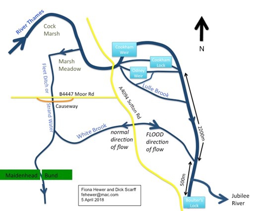
The causeway runs parallel to the B4447 Moor Road for about 350m between the Pound and the High Street. It is the only driving route into or out of Cookham village when the three usual roads (B4447, A4094 Ferry Lane, A4094 Sutton Road) are closed by flooding of the River Thames. This happens when the river rises to a height of 1.180m. The causeway is above the water level when the river is 1.460m high, but if the river rises further , it would eventually close too.
The Royal Borough of Windsor and Maidenhead (RBWM) is responsible for opening and managing the causeway at the point when all three routes are impassable. Causeway will be controlled by traffic lights. The Causeway opening times along with diversions and road closures are normally published on the Borough Council website.
During a flood, when all three roads are closed, limited access to the causeway will be given for vehicles under 3.5 tonnes. Both vehicles and pedestrians will be allowed to use the causeway, sometimes at the same time, and care should be taken by both when using this area. At certain points in the day the causeway will be closed to vehicles to allow pedestrian only access.
Please take care on the causeway. It is a narrow unfenced road and the water on either side can be fast flowing and 5 ft deep.

Cookham Waterways
Click the Link to see the
Cookham Lock Current River Level Live View
> gaugemap.co.uk/#!Map/Summary/1129/1224
River level information
0.60m – the normal range at Cookham Lock is 0 to 0.60 metres,
flooding (in fields) is possible above 0.60m.
0.967m – level recorded at midday on 5th January 2024 when water first present on Moor Rd.
1.00m – at this level the Moor Road (B4447 west of Cookham High Street) started to flood in 2013, 2014.
1.18m – at this level Sutton Road at Widbrook Common floods
1.12m – the approximate level that the A4094 north of Cookham Bridge floods.
1.46mASD – Highest level (in these records) was recorded in January 2003
1.36mASD – Highest level in February 2014
1.34mASD – Peak level recorded on 8th January 2024
‘mASD’ is a measure in metres of the height of rivers relative to a fixed point (local Stage Datum).

